DFG PAK 823-825: Remote sensing as surrogate for phylodiversity and functional processes along land use and elevation gradients. [funded by DFG] - Status: closed
Project staff:
Prof. Dr. Jörg Bendix
Abstract:
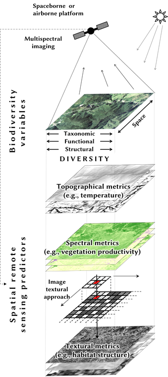
.png) In the proposed project we analyzed the potential of multispectral remote sensing data to model taxonomic and functional aspects of biodiversity in a tropical mountain rainforest in southern Ecuador. In particular, vegetation indices from multispectral reflectances and their textural information were used. For this purpose (i) different taxonomic groups and diversity measures (e.g. alpha/beta diversity) were investigated, (ii) a comparison to topographic metrics was made, and (iii) sensor data with high and moderate spatial resolution were considered.
In the proposed project we analyzed the potential of multispectral remote sensing data to model taxonomic and functional aspects of biodiversity in a tropical mountain rainforest in southern Ecuador. In particular, vegetation indices from multispectral reflectances and their textural information were used. For this purpose (i) different taxonomic groups and diversity measures (e.g. alpha/beta diversity) were investigated, (ii) a comparison to topographic metrics was made, and (iii) sensor data with high and moderate spatial resolution were considered.
The results of three working packages showed that the potential of multispectral remote sensing is closely related to the environmental filters of the respective biodiversity measures, which are responsible for spatial patterns of taxonomic and functional diversity. The taxon-specific resource requirements and their specific adaptation strategies to the environment are decisive for the importance of the predictors used here. In particular texture metrics, as proxies for habitat structure, explained a high proportion of diversity as additional predictors to topographic metrics. However, their potential depended both on the spatial resolution of the multispectral sensor and on the complexity of the texture calculation. The robustness of multispectral image textures as an important driver of taxonomic and functional diversity should therefore be further investigated.

(further information on the official project website: http://www.tropicalmountainforest.org/content_subprojects.do?phase=3&subpage=aims&subprojectid=208 and in the dissertation of Christine Wallis: https://archiv.ub.uni-marburg.de/diss/z2019/0058)
(photo: Cyanocorax Yncas, Yvonne Tiede)
Description:
In three working packages (WPs) we addressed variations in predictability of species diversity and functional trait values (as a proxy for ecosystem functioning).
WP1:
In the first working package, optical texture metrics were derived from a spatially very high-resolution satellite image (Quickbird). These were tested as predictors of Shannon diversity, phylodiversity, and the species composition of birds and compared with structural metrics of an active sensor (lidar). On the basis of texture metrics it was possible to model Shannon diversity, but not phylodiversity. Lidar metrics, on the other hand, showed a statistical correlation with phylodiversity, but not with Shannon diversity. The species composition, which describes the species turnover here, was successfully modelled from both data sources. However, the spatial predictions showed a strong correlation with the topography of the region. Consequently, it was shown that the potential of multispectral image metrics in the modeling of taxonomic diversity depends on the diversity measure. Our findings reveal a high potential of optical texture metrics for predicting Shannon diversity and a measure of community composition, but not for modeling phylodiversity. Generalizing from the investigated tropical mountain ecosystem,we conclude that texture information retrieved from multispectral data of operational satellite systems could replace costly airborne laser-scanning for modeling certain aspects of biodiversity.
WP2:
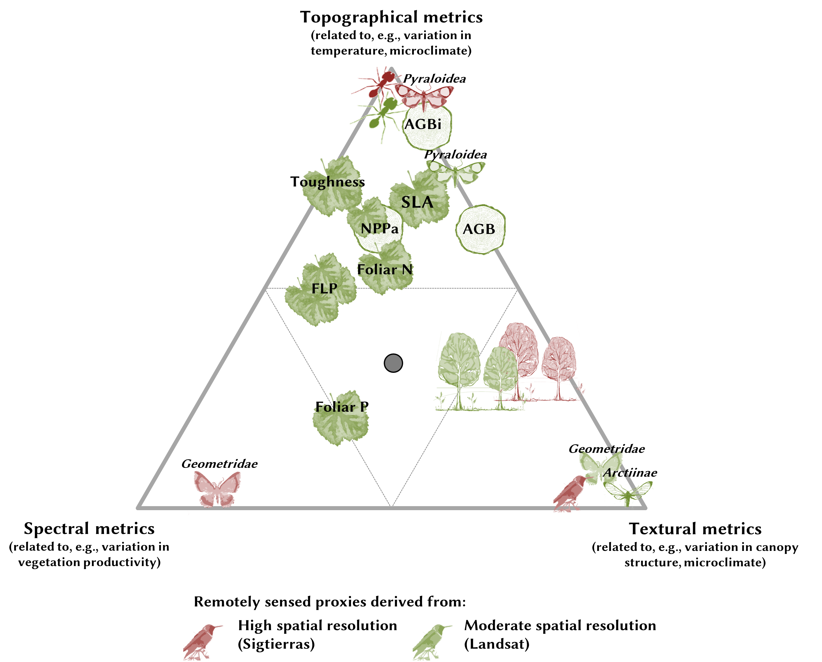
In the second WP, the species richness as well as the species turnover of six taxonomic groups were investigated. While the species richness of Pyraloidea (Lepidoptera) and ants was mainly determined by topography, the models of other taxonomic groups of Geometridea and Arctiinae (Lepidoptera) as well as trees and birds showed a stronger correlation of species richness with spectral metrics and image textures. A comparison between airborne and spaceborne multispectral data showed differences in the modeling of Geometridea and Arctiinae richness as well as birds. While for spatially high-resolution airborne orthophotos spectral vegetation indices were sufficient to model Geometridea, moderately resolved satellite data (Landsat-8) determined the richness of Geometridae and Arctiinae species solely by texture metrics. The models of bird species showed that only texture metrics from multispectral data at high spatial resolution were able to model their richness, while no model could be derived from Landsat data. A taxa-independent trend for the predictors was observed for the species turnover. This changed on the one hand with elevation a.s.l. and topography, on the other hand with different image texture metrics, independent from the spatial resolution of the underlying multispectral data. Consequently, the potential of multispectral remote sensing differed between taxa as well as spatial resolution of the multispectral sensor.
 WP3:
WP3:
In the third WP, biodiversity variables related to ecosystem functioning, including forest biomass, forest productivity and functional leaf traits of the canopy, were modeled using Landsat data. It was found that with changing species composition of trees along the topography gradient (WP2) also some functional traits changed. Forest biomass, annual wood growth and morphological leaf traits, such as leaf toughness and specific leaf area, decreased with increasing elevation and increased in the case of leaf toughness, respectively. The production of fine litter as well as biochemical leaf traits, in particular the foliar phosphorus concentration, showed, in addition to topography, a strong statistical correlation with vegetation indices and texture metrics. A broadband index from the visible wavelength bands (red and blue) provided complementary information to topography and led to a significant improvement of the models of biochemical leaf traits and fine litter production. These models also benefited from complex texture metrics as proxies for the habitat structure.
Publications and poster presentations:
2021 - Wallis, C.I.B.; Tiede, Y.; Beck, E.; Böhning-Gaese, K.; Brandl, R.; Donoso, D.A.; Espinosa, C.I.; Fries, A.; Homeier, J.; Inclan, D.; Leuschner, C.; Maraun, M.; Mikolajewski, K.; Neuschulz, E.L.; Scheu, S.; Schleuning, M.; Suárez, J.P.; Tinoco, B.A.; Farwig, N. & Bendix, J. (2021): Biodiversity and ecosystem functions depend on environmental conditions and resources rather than the geodiversity of a tropical biodiversity hotspot. Scientific Reports 11(1), 24530.
2019 - Wallis, C.I.B.; Homeier, J.; Peña, J.; Brandl, R.; Farwig, N. & Bendix, J. (2019): Modeling tropical montane forest biomass, productivity and canopy traits with multispectral remote sensing data. Remote Sensing of Environment 225, 77-92.
2017 - Wallis, C.I.B.; Brehm, G.; Donoso, D.A.; Fiedler, K.; Homeier, J.; Paulsch, D.; Süßenbach, D.; Tiede, Y.; Brandl, R.; Farwig, N. & Bendix, J. (2017): Remote sensing improves prediction of tropical montane species diversity but performance differs among taxa. Ecological Indicators 1(1), 1-11.
2016 - Wallis, C.I.B.; Paulsch, D.; Zeilinger, J.; Silva, B.; Curatola Fernández, G.F.; Brandl, R.; Farwig, N. & Bendix, J. (2016): Contrasting performance of Lidar and optical texture models in predicting avian diversity in a tropical mountain forest. Remote Sensing of Environment 174, 223-232.
