prime-RS Precipitation patterns, snow and glacier response in High Asia and their variability on sub-decadal time scales (prime) Sub-project Remote Sensing of precipitation (RS) [funded by DFG] - Status: closed
Project staff:
Dr. Boris Thies
Abstract:
 Precipitation is one of the most important climate elements linking complex atmospheric processes with hydrological cycles, snow cover and mass balances of glaciers and ice caps. Precipitation is a key variable for water resource management and prevention of natural disasters such as floods and droughts. This particularly holds true for the study region of the proposed project bundle prime which encompasses High Asia, i.e., the Tibetan Plateau and its surrounding high-mountain ranges.
- Research within prime aims at generating and validating improved gridded precipitation data sets relying on new remote sensing data and advanced numerical modelling approaches (i).
- Based on this we investigate spatial and temporal patterns and region-specific boundary conditions, large-scale drivers and meso- to local-scale processes controlling precipitation variability (ii).
- The improved accuracy and better knowledge on precipitation type and variability allow extending our understanding of spatial and temporal variations of glacier mass balances and seasonal snow covers in different sub-regions of High Asia (iii).
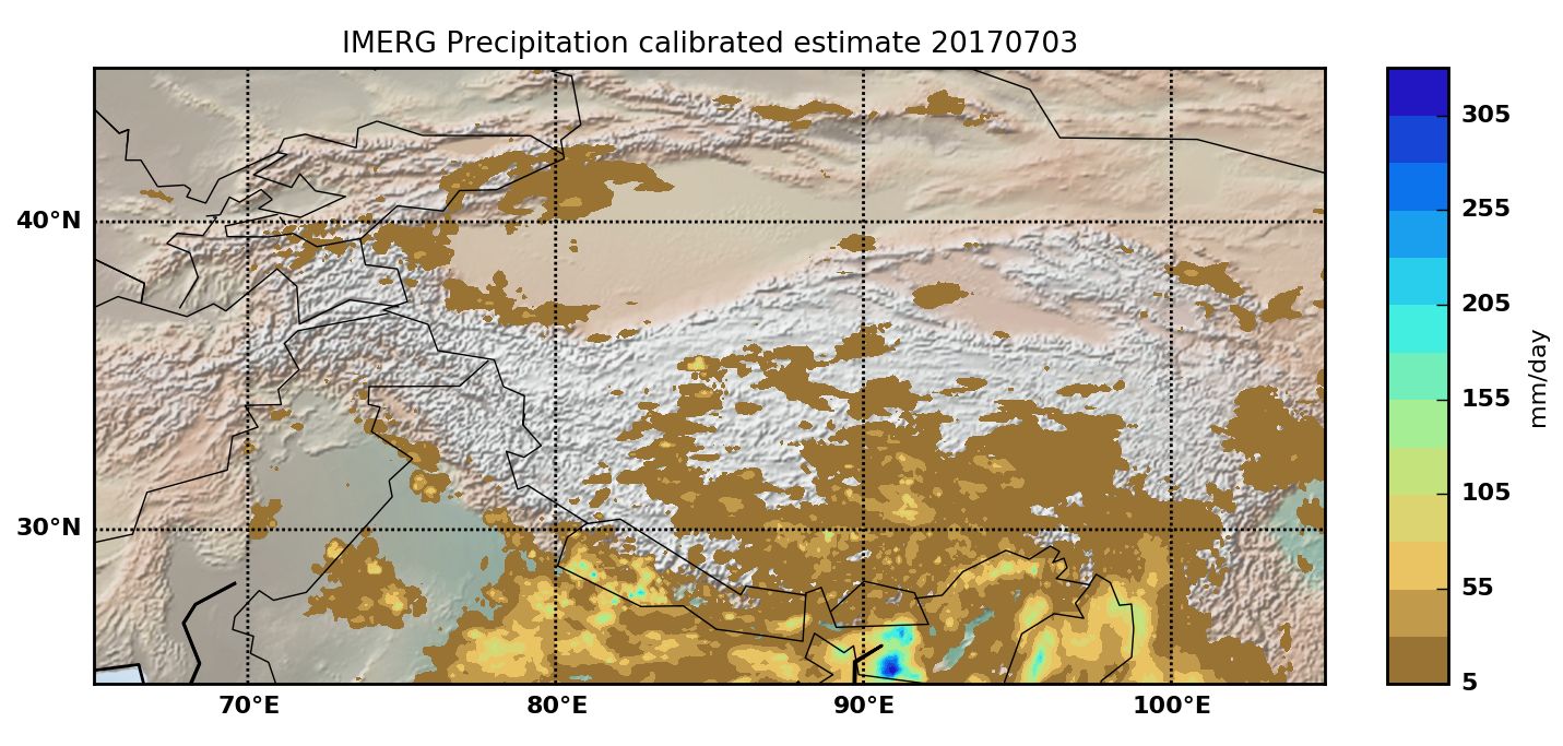
The aim of the proposed sub-project Remote sensing of precipitation (prime-RS) is the retrieval of precipitation information in a high spatio-temporal resolution over the Tibetan Plateau by means of satellite data for the period 2001 to 2018. Besides the retrieval of rainfall information one major focus is the retrieval of solid precipitation as a major parameter for glacier balances and the water cycle over the Tibetan Plateau. To provide the mentioned long-term precipitation time series with the highest possible accuracy we will combine first and second generation satellite data. The developed satellite-based precipitation products will benefit from an innovative cross-validation which incorporates high resolution reanalysis data over the Tibetan Plateau from TU Berlin together with detailed snow inventories provided by HU Berlin. By this means the proposed sub-project will provide a new system to properly observe atmo-hydro-cryosphere interactions over High Asia at high spatio-temporal resolution, suitable to capture cross-scale effects on the water balance. The detailed analysis of the new high resolution precipitation data set together with the improved high resolution reanalysis data set (TU Berlin) will provide new insights into the precipitation processes in High Asia and how they are governed by cross-scale atmospheric circulation dynamics.
Research partners: https://www.geographie.hu-berlin.de/de/abteilungen/klimatologie/forschung/klimawandel-und-gletscherforschung/prime-sg


Elektro-L2 (VIS 0.57 µm und IR 10.7 µm)
DGM Tibet
Publications and poster presentations:
2022 - Thiemig, V.; Gomes, G.N.; Skøien, J.O.; Ziese, M.; Rauthe-Schöch, A.; Rustemeier, E.; Rehfeldt, K.; Walawender, J.; Kolbe, C.; Pichon, D.; Schweim, C. & Salamon, P. (2022): EMO-5: a high-resolution multi-variable gridded meteorological dataset forEurope. Earth System Science Data 14(7), 3249--3272.
2020 - Hamm, A.; Arndt, A.; Kolbe, C.; Wang, X.; Thies, B.; Boyko, O.; Reggiani, P.; Scherer, D.; Bendix, J. & Schneider, C. (2020): Intercomparison of Gridded Precipitation Datasets over a Sub-Region of the Central Himalaya and the Southwestern Tibetan Plateau. Water 12(3271), 1-23.
- Kolbe, C.; Thies, B.; Turini, N.; Liu, Z. & Bendix, J. (2020): Precipitation Retrieval over the Tibetan Plateau from the Geostationary Orbit—Part 2: Precipitation Rates with Elektro-L2 and Insat-3D. Remote Sensing 12(13), 2114.
2019 - Kolbe, C.; Thies, B.; Egli, S.; Lehnert, L.; Schulz, M. & Bendix, J. (2019): Precipitation Retrieval over the Tibetan Plateau from the Geostationary Orbit — Part 1 : Precipitation Area Delineation with Elektro-L2 and Insat-3D. Remote Sensing 11(19), 2302.
