The project carries out the relevant measurements and process studies on a plot-based design at 11 locations aligned along an east-west transect from coast to coast, crossing the Renoso massif in central Corsica, thereby covering the full range of Corsican climates. Five master plots with full meteorological, hydrological, and dendroecological instrumentation were established in the coastal regions and mid-elevations of each declivity, and in the high-elevation belt. Six other plots supplement the data by temporary collection of tree-ring material and water samples. Specifically, automated weather stations (measuring air temperature, humidity, wind, rainfall, radiation, soil moisture, and soil temerature), electronic band dendrometers (measuring tree cumulative radial change) and rain collectors enable a continuous measurement at the five core sites. At two sites, soil suction probes were installed to obtain soil water samples. In time intervals of two to four weeks hydrological samples will be taken, complemented by collection of tree micro-cores, needles and branches. Rain collectors were set up at all 11 sites for a higher resolution of spatial and temporal variation of precipitation stable isotope distribution. An additional rain collector for analysing the isotopic signature of single rainfall events was installed in Corte where an accomadation serves as the base camp for the field activities.
The permanent equipment (5 climate stations, 12 rain collectors, 2 soil suction probes and 42 dendrometers) was installed in April 2017 and will run for at least two years.
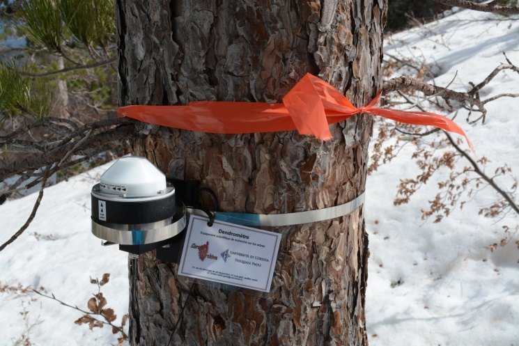
Pinus nigra tree equipped with a band dendrometer at site Capanelle.
Raincollector at site Sampolo.Climate station at site Capanelle.
The project will carry out the relevant measurements and process studies on a plot-based design at 11 locations aligned along an east-west transect from coast to coast, crossing the Renoso massif in central Corsica, thereby covering the full range of Corsican climates. Five master plots with full meteorological, hydrological, and dendroecological instrumentation for continuous measurements will be established in the coastal regions and mid-elevations of each declivity, and in the high-elevation belt. Six other plots will supplement the data by temporary collection of tree-ring material and water samples. The expected newly developed tree-ring chronologies, hydroclimate reconstructions and models derived from Corsica are planned to be embedded in a larger-scale context and can help to better evaluate future climate change scenarios for the western Mediterranean region.